Monday, 10 February, 1997
The two radar images of Mercury, captured using the VLA to map the radar
echoes, show strong reflections from the poles. These are caused most likely
by water ice trapped in areas in permanent shadow in the floors of craters
and then covered with a thin layer of regolith.
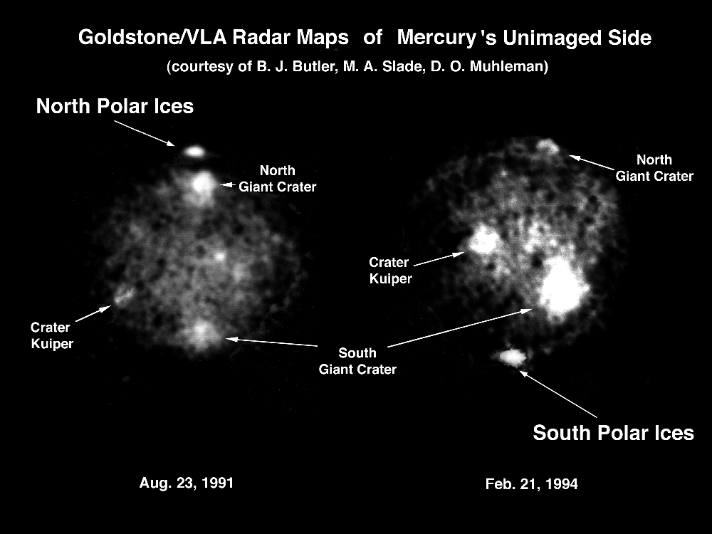
The August 1991 image showing the North pole like a lighthouse was a very
great surprise. The result, first announced at a planetary science conference
in late 1991, excited enormous interest both among scientists and the broadcast
and print media. Some British, in the form of the BBC in London, were sure
that ice, as water, could support a colony near the Mercury poles; this,
despite the fact that the days of colonization are over.
The full account of the work appeared in 1992:
M. A. Slade, B. J. Butler, D. O. Muhleman, Science 258, 635 (1992)
1994 observations showed the same result for the South pole.
We obtained these images by observing the Radar echo with the VLA in
New Mexico.
We transmit radar signals towards Mercury. The echoes return to Earth. Some
echo power is received by each of the 27 antennas of the VLA. Since the
the VLA is an interferometer we may combine all the echoes to construct
a two dimensional picture, the "power brightness distribution"
of a portion of the sky which includes the disk of Mercury. We can view
the poles because the planes of the Earth's orbit and that of Mercury are
at an angle. Sometimes we "look down" on the North pole, at other
times we "look up" at the South pole.
We expect there to be a good deal of power reflected from the equatorial latitudes of the planet. This reflection will be especially strong in the center of the disk where the Radar signal hits the planet surface head on - rather like looking at a mirror straight on. But at the poles the angle the signal makes with the surface is very shallow, almost parallel to the surface, since this is curving strongly away from us. It is rather like the path of a stone you throw to skim across the surface of water. Such stones bounce off and ever further away from the thrower. They do not bounce back. But the Radar signal does, and strongly! Not at all what you might expect, but real enough, and repeated with the 1994 observations of the South pole. The effect is called "coherent backscatter" (CBS), which produces more photons in the "non-mirror" sense than in the mirror sense, but, in both cases, far more photons than
The simplest physical explanation is ice - frozen water - at the poles. This finding caused so much sensation when made public since no one expected ice to exist on a planet "so close to the Sun", "so hot", "where the 'daytime' high temperature rises, as it has for billions of years, to a merciless 430 C". But this is actually only at the Mercury equator. Mercury is unusual in that its axis of rotation is exactly at right angles to the plane of its orbit about the Sun. In contrast the Earth's axis is tilted 23-1/2 degrees to the orbital plane, which gives us seasons. Mercury does not have seasons as we understand the term. At the poles the local highs will be much lower. But ... there are places at the poles where the temperature never gets above the night-time low of -170 C.
Like the Moon, Mercury is covered in craters - a surface unchanged since the "heavy bombardment" phase of the early Solar System 3 billion years ago, when all the inner planets were devastated by repeated impacts of the cometary material left over from Solar System formation.
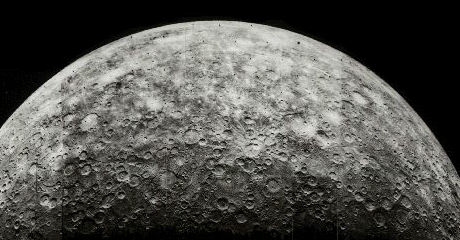
The polar regions of Mercury are as crater pockmarked as the rest of the planet surface. The high walls and deep floors of some of these mean that large parts of the crater interiors are in perpetual shadow. No gleam of a sunny ray ever illumines, let alone warms, these regions. Icy material deposited billions of years ago remains in frozen state, eternally imprisoned, just as the permafrost in Artic tundra on Earth. It is and always has been too cold for this frozen matter to melt or even to sublimate, and thus to escape into Space. It has remained there since the formation of the Solar System, unknown, unsuspected, and undetected ... until the enquiring glow of our Radar signal, peeking into their Stygian gloom caused the water moledules to re-radiate, over the lips of the crater walls back to Earth.
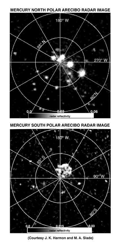
The "frosting" on this pleasing Radar cake was the full disk
high resolution mapping performed concurrently from Arecibo at 2.4 GHz.
This showed that the areas of polar reflection are many, discrete, small
(15 to 60 km), and typically circular. Overlaying the map of the Radar reflections
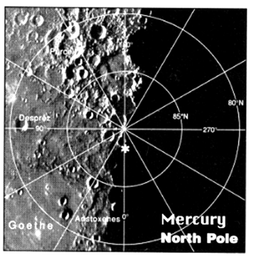
on the photographs of the polar regions taken by Mariner 10 in 1974 gives
an agreement little short of stunning with the polar crater positions. Some
features cannot be matched because those parts of the surface were in Mercury
night, not visible to the Mariner camera.
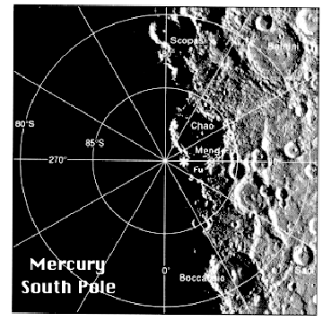
In 1994 the measurements
were repeated for the South pole. The correlation of the landscape with
the reflecting areas is similarly pleasing.
|
|
These results appreared in 1994:
J. K. Harmon, M. A. Slade, et al., Nature 369, 213 (1994)
We may confidently expect that the reflecting spots not yet matched will be craters. This verification however must await a Mercury orbiter mission and the next millenium
2: J. K. Harmon, M. A. Slade, et al., Nature 369, 213 (1994)